This article is written by Karel Charvát Junior and Jaroslav Šmejkal of Lesprojekt responsible for the DEMETER pilot ‘Data Brokerage Service and Decision Support System for Farm Management’.
Farmers and advisors providing services to farmers need to use large amounts of different types of data from different sources and perform analysis on this data for a better overview of the farm and to inform effective decision-making. There are a large number of different types of data and data analysis services that are relevant to farmers and agricultural advisors. Although some of this data is open, obtaining and preparing it for actual use on the farm is time and skill intensive in some cases. Data varies according to the sources of origin, format, quantity, and also meaning.
Lesprojekt, in collaboration with other partners, develops and operates decision support tools that are offered and made available to farms and agricultural advisors. To facilitate the decision-making process, it is crucial that the user has all the data and services required for a particular analysis and decision available through a single platform. These datasets and services in many cases have different owners and use different standards, formats and protocols.
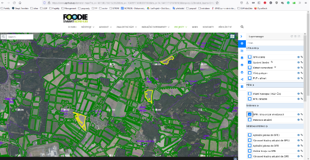
The infrastructure used by Lesprojekt involves portals for farmers and other agricultural data users based on HSLayers NG map client, using Micka as a metadata catalog and sensor solutions made available through Senslog.

Figure 1: An example of an agricultural data portal instance using the HsLayers NG client
For the use of DEMETER enablers, which have the potential to increase the value of the services offered by Lesprojekt, an approach was chosen that maximizes the possibilities of using DEMETER enablers while making only relatively small changes to existing platforms and services.
This approach is made possible by the DEMETER Agricultural Information Model (AIM) that DEMETER enablers use to receive requests and return results.
Since the DEMETER AIM includes mappings from several other well-known data models used in agriculture, such as the FOODIE data model, setting up input requirements and receiving results is a relatively straightforward process. If the platforms operated by Lesprojekt require a service provided by a certain DEMETER enabler, the inputs required by that enabler are transformed into the DEMETER AIM and the results provided by that DEMETER enabler are again transformed into the internal data models used by Lesprojekt tools. This loose approach to integration and data exchange with DEMETER enablers allows not only the ability to use enablers that are available now but also DEMETER enablers that may appear in the future.
In decision support tools offers by Lesprojekt, open data plays a key role. The open data are integrated with the farm’s internal data once a trust-based collaboration with the farm is established. The willingness of farms to adopt new services depends on the technical equipment of the farm, the capabilities of the staff, the value that the service can provide, and the cost of the service, including the time the farm needs to invest into implementing the service and preparing the data.
The time availability of agronomists who are able to use precision farming approaches, define requirements and provide feedback, has emerged as one of the key constraints for farms who may be potential users of the services offered. It is therefore important that communication with farms from initial contact is as efficient as possible. Some of the DEMETER enablers have the potential to increase the effectiveness of this communication and requirements definition at the initial stage of contact with farms. One example is the crop type detection DEMETER enabler.
At first glance, it may seem that this type of enabler is suitable only for public sector agencies dealing with CAP agendas, insurance companies or researchers, rather than for providing services to farms because agronomists already know what crops are grown in each field in a given season.
However, this is actually valuable information for service providers like Lesprojekt because in most countries crop type information is not included in the public part of the land-parcel identification system (LPIS).
Knowing the crop type therefore adds to the information available about the overall focus and profile of the farm, and allows a preliminary estimate of which fields on the farm might be most relevant for the provision of various other services and analyses.

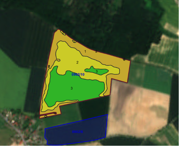
Image 2: Automatic zoning of winter wheat fields according to the EVI index.
For example, a nitrogen variable rate application map prepared based on long-term yield variability within a given field estimated from EarthObservation data may be more appropriate for crops such as barley or wheat than for other crop types such as sugar beet.
Such relevant information therefore allows for the adjustment of the initial service offering accordingly and for the preparation of background material and specific topics for further discussion. This will make the information as relevant as possible for the farms saving the precious time of agronomists and other people on the farms before they are willing to invest their time in sharing the farm’s internal data with the service provider.
This approach increases the chance of establishing a successful and efficient cooperation with the farm, which will help them to achieve positive effects such as saving the amount of fertilizers used, which means not only cost savings but also fewer negative environmental impacts.


